Research Highlights

Remote Sensing of Particulate Matter and Chemical Composition
[1] Developed machine learning approaches by considering the spatiotemporal heterogeneity of air pollution to improve the accuracy of daily PM2.5 estimates for high spatial resolution (1 km).
[2] First retrieved global daily 1 km gapless PM2.5 concentrations via machine learning and big data, revealing its spatiotemporal variability at an exceptionally detailed level everywhere every day.
[3] First reconstructed the PM2.5 data records back up to last two decades which makes up for the lack of observations in China and US, and the accuracy is the highest among all published results.
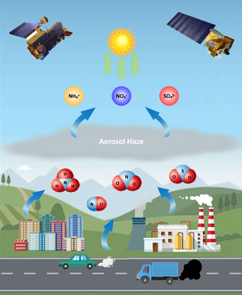
[4] First separated regional (China and US) daily 1 km PM2.5 chemical composition (e.g., BC, SO42-, NO3-, and NH4+) from satellite PM2.5 retrievals since 2000 via deep learning integrating ground measurements and big Data.
[5] Improved temporal resolution by deriving the diurnal variations in PM2.5 pollution from geostationary meteorological satellite using machine learning.
[6] Extended the machine learning approaches for estimating long-term daily particulate matter with different sizes, e.g., PM1 and PM10.
References:
[1] Wei, J.*, Li, Z., Lyapustin, A., Wang, J., Dubovik, O., Schwartz, J., Sun, L., Li, C., Liu, S., and Zhu, T. First close insight into global daily gapless 1 km PM2.5 pollution, variability, and health impact. Nature Communications, 2023, 14, 8349. https://doi.org/10.1038/s41467-023-43862-3 (ESI Hot and Highly Cited Paper, ESSIC 2024 Best Paper Award)
[2] Wei, J., Li, Z., Lyapustin, A., Sun, L., Peng, Y., Xue, W., Su, T., and Cribb, M. Reconstructing 1-km-resolution high-quality PM2.5 data records from 2000 to 2018 in China: spatiotemporal variations and policy implications. Remote Sensing of Environment, 2021, 252, 112136. https://doi.org/10.1016/j.rse.2020.112136 (ESI Hot and Highly Cited Paper, Journal Most Cited Articles since 2019/2020, Top 100 Most Cited Chinese Papers Published in International Journals, ESSIC 2022 Best Paper Award)
[3] Wei, J.*, Li, Z., Chen, X., Li, C., Sun, Y., Wang, J., Lyapustin, A., Brasseur, G., Jiang, M., Sun, L., Wang, T., Jung, C., Qiu, B., Fang, C., Liu, X., Hao, J., Wang, Y., Zhan, M., Song, X., and Liu, Y. Separating daily 1 km PM2.5 inorganic chemical composition in China since 2000 via deep learning integrating ground, satellite, and model data. Environmental Science & Technology, 2023, 57(46), 18282–18295.. https://doi.org/10.1021/acs.est.3c00272 (ESI Highly Cited Paper)
[4] Wei, J., Li, Z., Guo, J., Sun, L., Huang, W., Xue, W., Fan, T, and Cribb, M. Satellite-derived 1-km-resolution PM1 concentrations from 2014 to 2018 across China. Environmental Science & Technology, 2019, 53(22), 13265-13274. https://doi.org/10.1021/acs.est.9b03258 (ESI Hot and Highly Cited Paper)
[5] Wei, J.*, Li, Z., Xue, W., Sun, L., Fan, T., Liu, L., Su, T., and Cribb, M. The ChinaHighPM10 dataset: generation, validation, and spatiotemporal variations from 2015 to 2019 across China. Environment International, 2021, 146, 106290. https://doi.org/10.1016/j.envint.2020.106290 (ESI Highly Cited Paper)
TOC (PM2.5 and chemical composition):

Remote Sensing of Trace and Polluted Gases
[1] Offered a new perspective to estimate daily full-coverage ground-level O3 concentrations from solar radiation intensity and surface temperature using machine learning and big data, and explored the long-term trends of surface O3 pollution.
[2] Developed a novel interpretable spatiotemporally weighted artificial intelligence approach to estimate daily 1 km full-coverage ground-level NO2 concentrations from TROPOMI and OMI tropospheric NO2 columns and big data.
[3] Extended machine learning models to estimate the daily 10 km seamless ambient gaseous pollutants (NO2, SO2, and CO) with extensive input variables measured on monitors, satellites, and models.
References:
[1] Wei, J.*, Li, Z., Li, K., Dickerson, R., Pinker, R., Wang, J., Liu, X., Sun, L., Xue, W., and Cribb, M. Full-coverage mapping and spatiotemporal variations of ground-level ozone (O3) pollution from 2013 to 2020 across China. Remote Sensing of Environment, 2022, 270, 112775. https://doi.org/10.1016/j.rse.2021.112775 (ESI Hot and Highly Cited Paper)
[2] Wei, J.*, Liu, S., Li, Z., Liu, C., Qin, K., Liu, X., Pinker, R., Dickerson, R., Lin, J., Boersma, K., Sun, L., Li, R., Xue, W., Cui, Y., Zhang, C., and Wang, J. Ground-level NO2 surveillance from space across China for high resolution using interpretable spatiotemporally weighted artificial intelligence. Environmental Science & Technology, 2022, 56(14), 9988–9998. https://doi.org/10.1021/acs.est.2c03834 (ESI Highly Cited Paper)
[3] Wei, J.*, Li, Z., Wang, J., Li, C., Gupta, P., and Cribb, M. Ground-level gaseous pollutants (NO2, SO2, and CO) in China: daily seamless mapping and spatiotemporal variations. Atmospheric Chemistry and Physics, 2023, 23, 1511–1532. https://doi.org/10.5194/acp-23-1511-2023 (ESI Hot and Highly Cited Paper)
Remote Sensing of Atmospheric Aerosols
(i) Algorithm Development
[1] Developed an innovative framework for retrieving AOD from Landsat imagery over land, which leverages the deep-learning Transformer model (named AeroTrans-Landsat) and operates on the Google Earth Engine (GEE) cloud platform.
[2] Developed an improved high-resolution aerosol retrieval algorithm supported by a priori surface reflectance database (I-HARLS) for MODIS to generate the global 1-km AOD product over land.
[3] Developed a regionally robust high-resolution aerosol retrieval (RRHA) algorithm for MODIS by correcting the surface BRDF effects and refining the aerosol types over urban and complex surfaces.
[4] Extended the developed aerosol retrieval algorithms to various satellite sensors to improve the spatial resolution and length of data records, e.g., Landsat, and VIIRS.
References:
[1] Wei, J.*, Wang, Z., Li, Z., Li, Z., Pang, S., Xi, X., Cribb, M., and Sun, L. Global aerosol retrieval over land from Landsat imagery integrating Transformer and Google Earth Engine. Remote Sensing of Environment, 2024, 315, 114404. https://doi.org/10.1016/j.rse.2024.114404
[2] Wei, J., Li, Z., Peng, Y., Sun, L., and Yan, X. A regionally robust high-spatial-resolution aerosol retrieval algorithm for MODIS images over Eastern China. IEEE Transactions on Geoscience and Remote Sensing, 2019, 57(7), 4748–4757. https://doi.org/10.1109/TGRS.2019.2892813
[3] Wei, J., Li, Z., Sun, L., Yang, Y., Zhao, C., and Cai, Z. Enhanced aerosol estimations from Suomi-NPP VIIRS images over heterogeneous surfaces. IEEE Transactions on Geoscience and Remote Sensing, 2019, 57(12), 9534–9543. https://doi.org/10.1109/TGRS.2019.2927432
[4] Wei, J., Sun, L., Peng, Y., Wang, L., Zhang, Z., Bilal, M., and Ma., Y. An improved high-spatial-resolution aerosol retrieval algorithm for MODIS images over land. Journal of Geophysical Research Atmospheres, 2018, 123(21), 12291–12307. https://doi.org/10.1029/2017JD027795 (Journal Highlight)
[5] Wei, J., Huang, B., Sun, L., Zhang, Z., Wang, L., and Bilal, M. A simple and universal aerosol retrieval algorithm for Landsat series images over complex surfaces. Journal of Geophysical Research Atmospheres, 2017, 122(24), 13338–13355. https://doi.org/10.1002/2017JD026922
TOC (AeroTrans-Landsat AOD retrieval model):

(ii) Data Validation and Fusion
[1] Quantitatively evaluated and revealed the uncertainty of aerosol product algorithms under varying surface and atmospheric conditions for various satellites, e.g., MODIS, VIIRS , and Himawari-8.
[2] Inter-comparison the ability of various satellite aerosol products in describing the aerosol loadings and long-term variations of global AODs, and provide users a reference for data selection.
[3] Developed methods and improved schemes to merge the multi-source satellite aerosol products to improve the overall accuracy.
References:
[1] Wei, J., Peng, Y., Mahmood, R., Sun, L., and Guo, J. Intercomparison in spatial distributions and temporal trends derived from multi-source satellite aerosol products. Atmospheric Chemistry and Physics, 2019, 19, 7183–7207. https://doi.org/10.5194/acp-19-7183-2019 (ESI Highly Cited Paper, Cited By IPCC AR6)
[2] Wei, J., Li, Z., Peng, Y., and Sun, L. MODIS Collection 6.1 aerosol optical depth products over land and ocean: validation and comparison. Atmospheric Environment, 2019a, 201, 428–440. https://doi.org/10.1016/j.atmosenv.2018.12.004 (ESI Hot and Highly Cited Paper)
[3] Wei, J., Li, Z., Sun, L., Peng, Y., and Wang, L. Improved merge schemes for MODIS Collection 6.1 Dark Target and Deep Blue combined aerosol products. Atmospheric Environment, 2019, 202, 315–327. https://doi.org/10.1016/j.atmosenv.2019.01.016
[4] Wei, J., Li, Z., Sun, L., Peng, Y., Zhang, Z., Li, Z., Su, T., Feng, L., Cai, Z., and Wu, H. Evaluation and uncertainty estimate of the next-generation geostationary meteorological Himawari-8/AHI aerosol products. Science of the Total Environment, 2019, 692, 879–891. https://doi.org/10.1016/j.scitotenv.2019.07.326
Cloud Detection for Satellite Remote Sensing Imagery
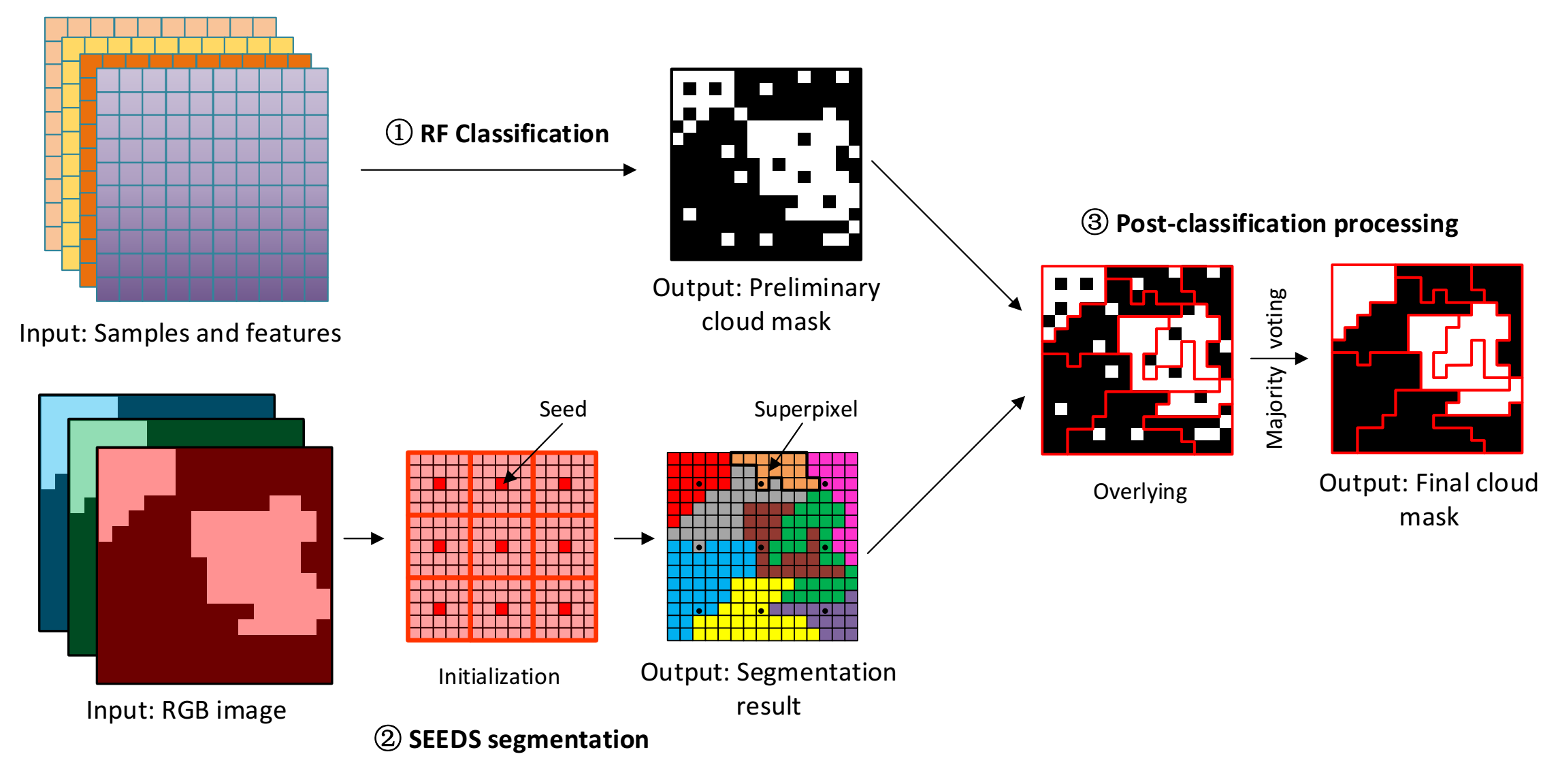
[1] Developed a RFmask algorithm to improve the accuracy of cloud identification for different Landsat sensors (e.g., TM, ETM+, and OLI) by combing the machine learning and the Super-pixels Extracted via Energy-Driven Sampling (SEEDS) segmentation approaches.
[2] Developed a new Universal Dynamic Threshold Cloud (Shadow) Detection Algorithm (UDTCDA) based on the priori surface reflectance database and radiative transfer simulations to improve the cloud mask for different satellites, e.g., Landsat, MODIS, and VIIRS.
[3] Extended varying Convolutional Neural Network (CNN) models to improve the global cloud detection accuracy for Landsat imagery, and applied to Sentinel-2 imagery via transfer learning.
References:
[1] Wei, J., Huang, W., Li, Z., Sun, L., Zhu, X., Yuan, Q., Liu, L., and Cribb, M. Cloud detection for Landsat imagery by combining the random forest and super-pixels extracted via energy-driven sampling segmentation approaches. Remote Sensing of Environment, 2020, 248, 112005. https://doi.org/10.1016/j.rse.2020.112005
[2] Sun, L., Wei, J.*, Wang, J., Mi, X., Guo, Y., Lv, Y., Yang, Y., Gan, P., Zhou, X., Jia, C., and Tian, X. A universal dynamic threshold cloud detection algorithm (UDTCDA) supported by a prior surface reflectance database. Journal of Geophysical Research Atmospheres, 2016, 121(12), 7172–7196. https://doi.org/10.1002/2015JD024722
[3] Pang, S., Sun, L., Tian, Y., Ma, Y., and Wei, J.*. Convolutional neural network-driven improvements in global cloud detection for Landsat 8 and transfer learning on Sentinel-2 imagery. Remote Sensing, 2023, 15(6), 1706. https://doi.org/10.3390/rs15061706
TOC (RFmask cloud detection algorithm):

Impact of Air Pollution
(i) Public Health
Investigated the associations and effects of short-term and long-term exposure to different species of air pollution (e.g., PMx, O3, No2) on human health (e.g., asthma, blood pressure, mortality, childhood pneumonia, lung cancer, et al.) using the CHAP dataset.
References:
[1] Wei, J.*, Wang, J., Li, Z., Kondragunta, S., Anenberg, S., Wang, Y., Zhang, H., Diner, D., Hand, J., Lyapustin, A., Kahn, R., Colarco, P., da Silva, A., and Ichoku, C. Long-term mortality burden trends attributed to black carbon and PM2.5 from wildfire emissions across the continental USA from 2000 to 2020: a deep learning modelling study. The Lancet Planetary Health, 2023, 7, e963–e975. https://doi.org/10.1016/S2542-5196(23)00235-8 Media Outlets (ESI Highly Cited Paper)
[2] Xu, R., Huang, S., Shi, C., Wang, R., Liu, T., Li, Y., Zheng, Y., Lv, Z., Wei, J.*, Sun, H., and Liu, Y. Extreme temperature events, fine particulate matter, and myocardial infarction mortality. Circulation, 2023, 148, 312–323. https://doi.org/10.1161/CIRCULATIONAHA.122.063504 (ESI Highly Cited Paper)
[3] Tian, Y., Ma, Y., Wu, J., Wu, Y., Wu, T., Hu, Y., and Wei, J.* Ambient PM2.5 chemical composition and cardiovascular disease hospitalizations in China. Environmental Science & Technology, 2024, 58(37), 16327–16335. https://doi.org/10.1021/acs.est.4c05718 (Journal Cover Article)
[4] Wang, L., Xu, T., Wang, Q., Ni, H., Yu, X., Song, C., Li, Y., Li, F., Meng, T., Sheng, H., Cai, X., Dai, T., Xiao, L., Zeng, Q., Guo, P., Wei, J.*, and Zhang, X. Exposure to fine particulate matter constituents and human semen quality decline: a multicenter study. Environmental Science & Technology, 2023, 57(35), 13025–13035. https://doi.org/10.1021/acs.est.3c03928
[5] Cai, M., Wei, J.#, Zhang, S., Liu, W., Wang, L., Qian, Z., Lin, H., Liu, E., McMillin, S., Cao, Y., and Yin, P. Short-term air pollution exposure associated with death from kidney diseases: a nationwide time-stratifed case-crossover study in China from 2015 to 2019. BMC Medicine, 2023, 21, 32. https://doi.org/10.1186/s12916-023-02734-9 (ESI Highly Cited Paper)
TOC (PM2.5 composition and cardiovascular disease):

(ii) Environment and Economy
Investigated the impacts of economic structure changes on air pollution, and the impacts of air pollution control on environmental regulation, etc.
References:
[1] Xue, W., Zhang, J., Zhong, C., Li, X., and Wei, J.* Spatiotemporal PM2.5 variations and its response to the industrial structure from 2000 to 2018 in the Beijing-Tianjin-Hebei region. Journal of Cleaner Production, 2021, 279, 123742. https://doi.org/10.1016/j.jclepro.2020.123742 (ESI Highly Cited Paper)
[2] Li, X., Xue, W., Wang, K., Che, Y., and Wei, J.* Environmental regulation and synergistic effects of PM2.5 control in China. Journal of Cleaner Production, 2022, 337, 130438. https://doi.org/10.1016/j.jclepro.2022.130438
[3] Lin, H., Zhu, J., Jiang, P., Cai, Z., Yang, X., Zhou, Z., and Wei, J.*. Assessing drivers of coordinated control of ozone and fine particulate pollution: Evidence from Yangtze River Delta in China. Environmental Impact Assessment Review, 2022, 96, 106840. https://doi.org/10.1016/j.eiar.2022.106840